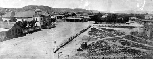
Los Angeles Plaza, Pre-1869. Image courtesy of the California Historical Society Collection, USC Libraries. [1]
|
Early Years: El Pueblo 1781-1867 |
Founding El Pueblo
In the late 18th century, European settlement of the land now known as Southern California was still in its infancy. At that time the California coast was part of a Spanish colony known as Alta California - part of the territory of New Spain. The site that would one day become Los Angeles was first visited by Gaspar de Portolà and Franciscan missionary Juan Crespí in 1769. In 1771, Franciscan friar Junípero Serra built Mission San Gabriel Arcangel, the first mission in the area. [2] In June of 1777, hoping to head off imperial ambitions by the Russians and the British, Spanish governor Felipe de Neve began asking for settlers for a new Pueblo. Farming towns were needed to support the Franciscan missions and military presidios already being established in the region. In 1781 the settlers (known as Los Pobladores) arrived, and Governor Neve began laying out the site. He planned it in accordance with the Laws of the Indies - a standardized layout for all Spanish colonies in the Americas - which called for a town square with houses on three sides and the church and public buildings on the fourth. The new settlement was named El Pueblo de la Reina de Los Angeles - Town of the Queen of the Angels. [3] In 1786, Spanish soldier José Darío Argüello detailed Neve's plan into the first planning map of the Pueblo (bottom right). [1]
In the late 18th century, European settlement of the land now known as Southern California was still in its infancy. At that time the California coast was part of a Spanish colony known as Alta California - part of the territory of New Spain. The site that would one day become Los Angeles was first visited by Gaspar de Portolà and Franciscan missionary Juan Crespí in 1769. In 1771, Franciscan friar Junípero Serra built Mission San Gabriel Arcangel, the first mission in the area. [2] In June of 1777, hoping to head off imperial ambitions by the Russians and the British, Spanish governor Felipe de Neve began asking for settlers for a new Pueblo. Farming towns were needed to support the Franciscan missions and military presidios already being established in the region. In 1781 the settlers (known as Los Pobladores) arrived, and Governor Neve began laying out the site. He planned it in accordance with the Laws of the Indies - a standardized layout for all Spanish colonies in the Americas - which called for a town square with houses on three sides and the church and public buildings on the fourth. The new settlement was named El Pueblo de la Reina de Los Angeles - Town of the Queen of the Angels. [3] In 1786, Spanish soldier José Darío Argüello detailed Neve's plan into the first planning map of the Pueblo (bottom right). [1]
|
The "Walking City"
Interestingly enough, El Pueblo de Los Angeles didn't grow very rapidly, and remained a small settlement well into the late 19th century. As a result, Los Angeles was able to 'skip' much of the urban reversal that took place in older cities during the 19th century transportation revolution. In his book "Los Angeles and the Automobile: The Making of the Modern City", author Scott L. Bottles describes early cities as "walking cities", because literally everyone walked. Only the richest and most affluent upper class could afford to ride in horse-drawn carriages (or even keep horses at all), and thus early city sizes were limited based on how far the common person could walk. This ultimately limited outward urban growth to about two miles, which is the average distance a person can walk in half an hour. [4] Early American cities like Philadelphia, Boston and New York experienced a massive continuous influx of new residents following the Revolution, and unable to expand outward they were forced to pack their residents closer together instead. In the early 19th century, population densities were as high as 75,000 people per square mile. In contrast, the average population density of New York City in 1980 was only 35,000 people per square mile, and is only about 27,000 people per square mile at present. [4] [5] Space became the most important commodity in these cities, and middle and upper class citizens lived in tiny row houses, while the poor and lower class were crammed into multifamily apartments, and often lived in slums. However what both the rich and the poor shared in common was their mutual need to live close to the urban city center, because that's where the jobs, commercial and retail areas were concentrated. This resulted in a complicated spatial integration of workplace and residence, where many workers and employers lived adjacent to their business in a kind of integrated familial atmosphere. [6] |
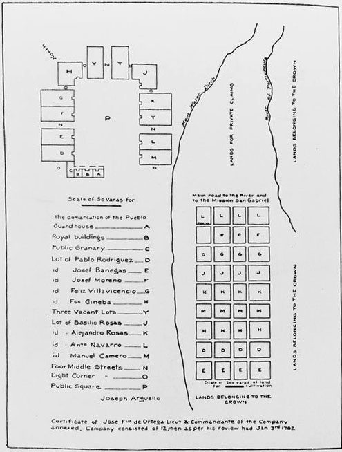
Reproduction of Argüello's 1786 town plan, translated to English. Image courtesy of the California Historical Society Collection, USC Libraries. [1]
|
Spatial Transformation of the Urban Environment
Ironically, the periphery of the "walking city" - what would one day become the suburbs - was considered the least desirable place to live back then. It was the sort of place you'd find slaghterhouses and tanneries, and where only the poorest and most unskilled workers could afford to live. However by the mid-nineteenth century, two factors allowed for the spatial transformation of the city to begin to take place. First, the industrial revolution and the introduction of the factory system separated the working class from living in the workplace with their employers. Factory owners also began to further introduce "spatial and psychological barriers" between themselves and their workers and break down the traditional familial relationship between employer and employee. [7] Second, after the 1830s a rapid influx of European immigrants caused the populations of most U.S. cities to skyrocket. They grew so rapidly that not only was the population density unbearably tight, but many basic services like water delivery and waste disposal were completely overwhelmed, and public health suffered. The U.S. city population grew on average by a staggering 92% in the 1840s alone! [8] This unprecedented growth convinced many of the middle- and upper-class to escape the uncomfortable congestion of the urban center and settle out in the countryside.
New transportation infrastructure was needed to get these upper-class urban refugees back to the city center for commerce and employment. This began with the "Omnibus" (a large capacity horse-drawn cab) and the horse-drawn streetcar, which began to appear between the 1830s-1860s. However it would not be until the advent of the steam locomotive and the electric streetcar that growth in Los Angeles would really take off.
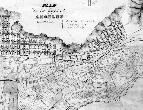
Edward O. C. Ord's 1849 map of Los Angeles. Even by the mid-nineteenth century, L.A. was still a fairly small town. Image courtesy of the Title Insurance and Trust / C.C. Pierce Photography Collection, USC Libraries. [1]
References
1. Nathan Masters, "Happy Birthday, Los Angeles! But is the Story of the City's Founding a Myth?" KCET, September 1, 2011, http://www.kcet.org/updaily/socal_focus/history/la-as-subject/birth-of-the-pueblo-of-los-angeles-los-pobladores-and-la-as-a-spanish-colonial-outpost.html (accessed on July 29, 2013).
2. Wikipedia contributors, "Los Angeles: History," Wikipedia, The Free Encyclopedia, http://en.wikipedia.org/wiki/Los_Angeles#History (accessed on July 29, 2013).
3. Jean Bruce Poole and Tevvy Ball, El Pueblo: The Historic Heart of Los Angeles (Los Angeles: Getty Publications, 2002), 7-9.
4. Scott L. Bottles, Los Angeles and the Automobile: The Making of the Modern City (Berkeley and Los Angeles: University of California Press, 1987), 5.
5. Wikipedia contributors, "List of United States Cities by Population Density," Wikipedia, The Free Encyclopedia, http://en.wikipedia.org/wiki/List_of_United_States_cities_by_population_density (accessed on July 29, 2013).
6. Scott L. Bottles, Los Angeles and the Automobile: The Making of the Modern City (Berkeley and Los Angeles: University of California Press, 1987), 6.
7. Scott L. Bottles, Los Angeles and the Automobile: The Making of the Modern City (Berkeley and Los Angeles: University of California Press, 1987), 7.
8. Scott L. Bottles, Los Angeles and the Automobile: The Making of the Modern City (Berkeley and Los Angeles: University of California Press, 1987), 8.
